Showing posts with label Temple. Show all posts

Monday, February 18, 2013

Jeju Island: Exploring a Gem of the Pacific

Last week, two friends and I decided to take advantage of our final long weekend in the country during Seollal (설날) - also known as the Lunar New Year - and hop on a ferry to what is reputed to be the most beautiful place in all of Korea - Jeju-do!

Recreations of the famous Jeju hareubang statues.
For those who don't know, Jeju (제주) is a small (73km by 41km) oval-shaped volcanic island 130km off the southwest tip of the Korean peninsula. Famed for it's beauty and often called 'the Hawaii of Korea', Jeju was recently named one of the New 7 Wonders of the Natural World - and I have to say, even in winter, Jeju lives up to it's hype.

Exploring the rock formations on the southern coast of Jeju.
While the 2 million year old island is literally littered with mini extinct volcanoes (360 of them to be exact), volcanic craters and lava tubes surrounding the main volcano of Hallasan (한라산) - also Korea's tallest mountain, coming in at 1950m (more on that in the next post!) - these are only part of what make the island so spectacular.

In addition to having a unique geology, Jeju's relative isolation has given it a unique cultural history. While Jeju was eventually annexed by the mainland Goryeo Dynasty in 1105 and the Mongols after that, then returned to Korea with the takeover by the Joseon Dynasty (who used it as a place to send political exiles) in 1404, and thus has shared much of it's more recent history (such as Japanese occupation) with the mainland, prior to this, Jeju-nese history is somewhat of a mystery.

Cheonjiyeon Falls (천지연 폭포) from a distance. You can see Hallasan rising into the clouds on the right.
Very little is known about the pre-Goryeo Tamma Kingdom and how it came to be. Island legend states that the three demigods: Go, Bu and Yang, rose out of the ground and became the islands first residents. When the three men were out hunting one day, they ran across three princesses who had washed ashore with all of their agricultural accoutrements and livestock. Marrying these three women, the hunters settled down and established the three main agricultural clans of Jeju island. The hole in the ground from which the hunters emerged can still be visited at Samsunghyeol Shrine (삼성혈)- which remains an important location for the seasonal ancestral rites performed by their descendants - in Jeju City.

A stone ring and tripple alter surround the hole through which Go, Bu and Yang entered Jeju at Samsunghyeol.
Other unique features of Jeju-nese culture include thatched roof houses - although these can only be seen today in the preserved traditional 'folk villages', the inexplicable ancient basalt mushroom-like grandfather statues called Dol Hareubang (돌 하르방) which dot the island, the hand-stacked stone dividing walls to allow for Jeju's famous winds to pass through without toppling them and, last but certainly not least, the haenyeo (해녀) - Jeju's famous women divers. Although now somewhat of a dying breed, women began to do the work of diving into the waters along the coast to collect shellfish in the 19th centuries when their husbands discovered that their families would be tax exempt if they did so!

As interested as I am in culture, as much as I loved hiking Hallasan and as fascinating as the publicly accessible portion of the lava tubes at the UNESCO World Heritage Site of Manjanggul (만장굴), geologically speaking, it was the coastline that took my breath away!

Looking toward Munseom (island) from some of the Rock formations along the coast in Seogwipo.
While the northern coastline around Jeju City (제주시) has some fun rocks, it's the south near Seogwipo (서귀포) that is really stunning. Not only is the area around Seogwipo studded with waterfalls, to the West of the city lies the resort area of Jungmun (중문), home to Korea's Jusangjeolli (주상절리) or  'Black Beach', made of hexagonal basalt formations reminiscent a smaller version of the Giant's Causeway connecting Scotland and North Ireland. While Jeju's Jusangjeolli is not as large as the Giant's Causeway, the emerald blue (no, really, that's the only way to describe the colour!) water the rocks rise out of makes it breathtaking to visit.

Jusangjeolli. The colour of the water made me nearly desperate to jump in - and it was February!

Jungmun is also home to Yakcheon Temple. While I have seen a lot of temples during my time in Korea, Yakcheonsa is ranks up there with my favourites. Done up in a more ornate style that reminds me more of the temples I've seen in Taiwan than any I've seen in Korea, the combinations of pastels and golds, as well as the amazingly detailed latticework carvings on the windows made a visit well worthwhile.

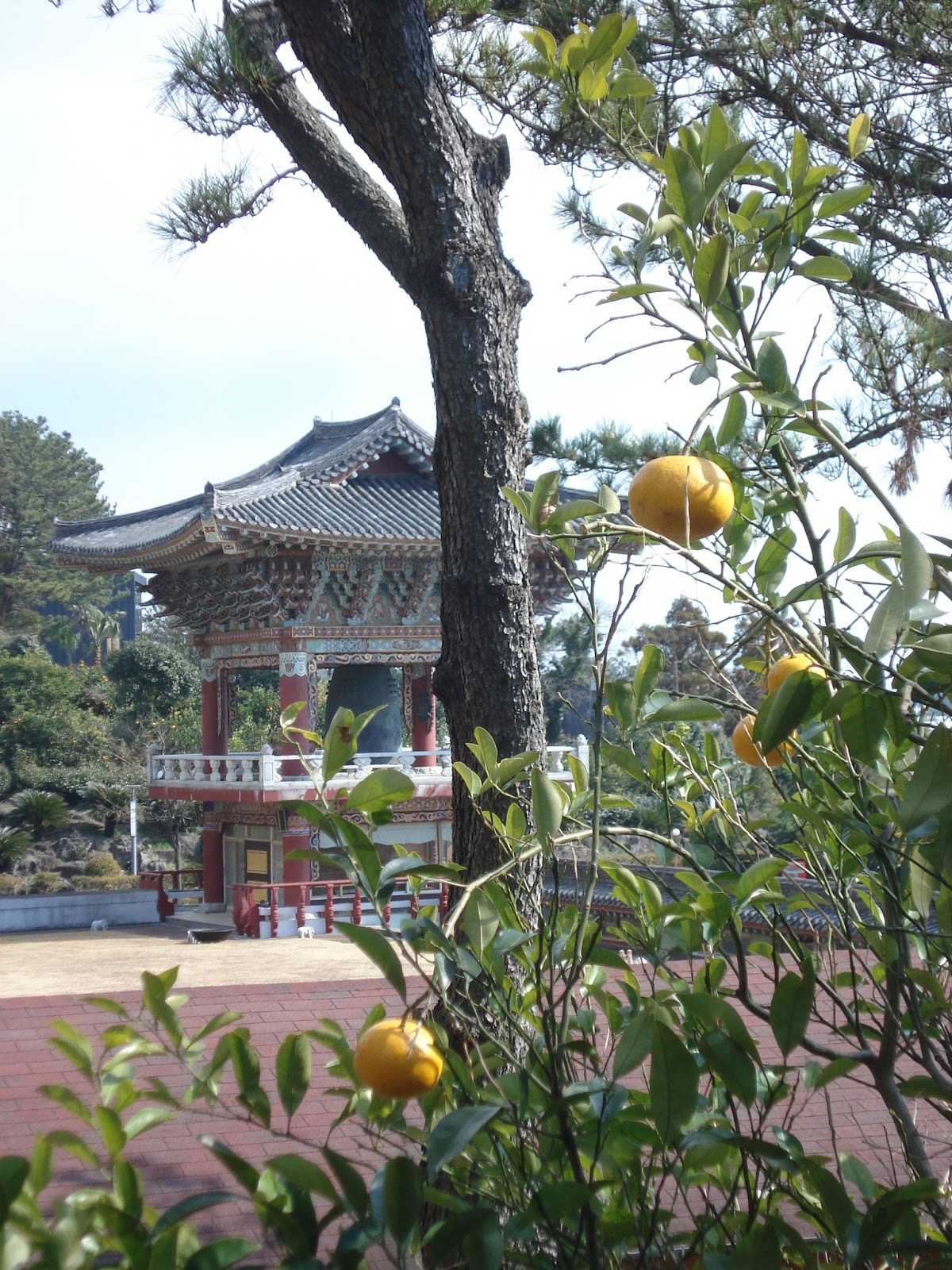
The bell tower at Yakcheonsa with oranges in the foreground. In addition to being famed for it's beauty, Jeju is famed for the deliciousness of it's oranges. Sadly, I was there a month too early for these ones to be ripe.

The giant gold Buddha inside Yakcheonsa. The great hall is said to be one of the biggest in Asia. With three floors of viewing galleries, each surrounded with painted panels depicting stories, I may well believe that.
Even further to the west along the southern coast was quite possibly my favourite spot on the island - the Yongmeori (용머리 - dragon's head) Peninsula. While it's invisible until you are down there and closed off at high tide, the coast below Sanbang peak (삼방산) if formed of weathered vocanic cliffs and caves that just bed to be explored. This is also where the monument to Handrick Hamel - the Dutchman who washed ashore on Jeju in 1653, was captured and enslaved, eventually managed to escape with 7 others in 1666, and wrote a book bringing news of life in the Joseon-era Hermit Kingdom of Korea to the rest of the world - and recreation of his ship are located. The small Mt. Sanbang itself is also worth a visit as it is home to Sambanggulsa (삼방굴사) or Sambang Cave Temple.

Looking toward the Yongmeori Coast from Sambang Temple. Hamel's ship is just visible in between the temple and coast.
A view of Hamel's ship through his momument.

While Jeju is fairly small, the sheer number of protruding mini volcanoes can make getting around the island somewhat time consuming. It's possible to travel by public transport, but having a car (and in smaller areas, bikes) might be more convenient (you need an international drivers licence though). We were lucky enough to stay in a wonderfully accomodating hostel (the owner even fed us traditional New Year's Tteok-guk (rice cake soup) on Seollal!), which offered cheap tailor-made driving tours. You can check out B&B Pan here. The island is also crisscrossed by 'Olleh Trails', 200km of connecting walking trails which have been divided into 13 different routes - although on many you can jump it at any point along the path.

Looking back toward Sanbang while walking the coast.

Some of the formations on the Yongmeori coast. This one is about three times my height.

Some more of the crazy geological features.
There are a number of ways to get to Jeju. Flights leave from most of the larger city airports on a daily basis and ferries, from Incheon (Seoul, 14hrs), Mokpo (4hrs) and Wando (3hrs), to Jeju City on the North Coast leave just as frequently. The fastest Ferry, and the most convenient for us, is the JH Ferry run by Orange1 which leaves from Jangheung (장흥), near Yeosu in southern Jeollanamdo, and arrives at Seongsan (성산) on the west coast of the Island in 2 and a half hours. There is also a free shuttle bus run by the ferry company which connects Gwangju to Jangheung. Their website is here. Unfortunately, it is entirely in Korean.

A view of Ilchulbong (일출봉), or Sunrise Peak in Seongsan on the East Coast at Sunset.

Monday, February 4, 2013

Look at all the Deer! Day-Tripping to Nara

Located between 30 and 45 minutes (depending on the speed of your train) from both Kyoto and Osaka, Nara is the perfect day trip location when it comes to providing a break from the pace of either city life in latter or the back-to-back, never-ceasing cultural sites that fill the former.

Standing outside of the Daibutsu-den Hall of Todai-ji.

Although filled with cultural sites of it's own - it was, after all, once the capital of Japan (prior to its movement to Kyoto later in the 8th century) - Nara's relatively small size and the fact that most of its sites are arrayed around Nara-koen, Nara's deer-filled park, make it seem much more manageable and much less overwhelming than Kyoto. 

To say that the deer are absolutely everywhere in Nara is simply the truth. To say that they go wherever they want is an understatement. To say that they are completely unafraid of humans is an even bigger one. I saw more than a few coats, bags and even backsides being lipped in the search for food. Here the deer are winding there way through some of the many hundreds of lanterns than line the way up to the Shinto shrine of Kasuga Taisha.
My favourite of the sites (and the only one pictured here) was, hands down, the Buddhist Temple of Todai-ji (500yen, 8am-4:30). Home to the famous Daibutsu, or Great Buddha, the temple was somehow simultaneously light, airy and awe-inspiring - bringing together all of the things that I imagine one should feel in the presence of those who have attained nirvana. It is, quite possibly, my favourite Buddhist temple - of a certainty, it's my favourite in Japan.

The Todai-ji Daibutsu, or Great Buddha. While this photo might not show it, the Daibutsu is one of the largest bronze statues in the world. Although this one was recast at some point during the Edo Period (17th- near 20th centuries), the original casting was done in 746.
 Guarded on either side by absolutely fierce-looking guardians, the hall housing the Daibutsu is nothing short of massive. Labelled as the largest wooden building in the world, it is actually a 1709 replica of the original - an original that was a third larger than the one in place now!

The Daibutsu-den Hall, aka, the largest wooden structure in the world.

To give some idea of its size, the statue above is 16 meters tall, and weighs in at around 437 tonnes of bronze and 130kg of gold. For a more personal demonstration of exactly what this means size-wise, please scroll down.

Forcing my way through a hole equivalent in size to the Daibutsu's nostril. Surprisingly, it wasn't that tight a fit! 

Tuesday, November 13, 2012

Beagyangsa & Reflections of the Fall

Last Monday, it was time, once again, for a teacher wellness expedition. As per usual at my school, this involved food and hiking - fortunately for me (as last Monday was the day after my 46km Jirisan hike), this time the hike was much more of a leasurely meander along stunningly reflective river-pools. 

One of the Baegyangsa Pavilions and it's reflection.
This particular teacher wellness hike saw us head out to the Baegyang Valley, home of Baegyang Temple (백양사), in Naejangsan National Park (내장산) - about an hour and a half north of Gwangju. Baegyang is famous for a number of things, the two most notable of these - particularly in the fall - are its persimmons (mmmm, persimmons! - more on those another time) and the spectacular colours of its leaves. I have to say, while I've seen a number of sumptuously coloured valleys in my time here thus far, Baegyang thoroughly deserves its reputation.


Looking toward Naejang Mountain.

Some of the riotously red leaves. I love just how many different colours there are in this one tree!

A doorway leeding to one of the cemetaries in the area.

A close-up of the path stones.

I just loved the myriad of colours in this shot.

Looking toward Baegyang's persimmon, or gam (감), grove.

One of the temple buildings.

Can't get enough of the combination of real and reflected.

Heading back from whence we came en route to dinner - which was comprised of surprisingly delicious prepared local roots and shoots.

A Long Trek - Crossing Korea's Jirisan National Park on Foot.

From the smallest to the largest. Last weekend I had the opportunity to hike across the 41km that comprises the spine of Jirisan (지리산 - Jiri Mountain) National Park. This to be contrasted with this weekend, which I spent largely doing nothing while lounging around my house reading novels ;).

The colours of the Hwaeom (화엄) Valley where we began our ascent. 
While the original plan had us hiking as a party of six, only two of us wound up actually doing the hike (the two boys dropped out early in the planning due to 'other commitments' and the other two girls unfortunately fell ill the week before). While I admit, the prospect of traversing 41km (46 actually if you consider the hike up to the trail head from our hotel and then down again into the village bus station at the other side) and 13 different peaks in only two days might be a little daunting, it was totally worth it - especially with all the colours showing at this time of year!

The colours along the road up to the Hwaeomsa (화엄사 - Hwaeom Temple) entrance.

Due to the time constraints imposed by having to work during the week, we decided to head out from the Hwaeomsa entrance at the western side of the park and hike eastward, ending our trek either at Daewon Temple (대원사) or at Jungsanni (중산니) in the east. This made it possible to hop on a bus from Gwangju to Gurye (구례) (1h30) on the Friday night and to take a cheap 6,000won taxi ride out to our pension near the temple for the night. (We had a Nore Taxi!(Korean kareoki) It was epic!) For the record, the Hwaeom Pension is great, hugely spacious, nice rooms with cooking facilities at very decent prices (less than 20,000/person). The rooms are traditional ondol-style (heated floor with blankets).

Hwaeomsa at roughly 7:15am.
We set out bright and early on the Saturday morning with the intention of trekking up to Hwaeomsa for a quick visit and then heading ownward from there. The 7km up from Hwaeomsa to Nogodan (1,430m) was arguably the hardest part of the trek. Beautiful, but hard. I'd previously seen it described as a 'long, slow slog' and when we started out, we thought that might be a bit of an exaggeration. It wasn't. If you want an easier route in, I recommend the 4.7km up from the Seongsamjae (성삼재) Pass.

This was a nice, un-evil, part of the path.

Getting even more beautiful as we rise...

Above to the point at which the trees have lost all their leaves.

The morning view from Nogodan (노고단) (1,430m).

Check out those clouds.

Walking the Dwaejiryeong Pass (돼지령).

Looking over the Piagol  Valley (피아골).

At the top of Samdobong (삼도봉), or Three Province Peak (1499m), so named because it represents the intersection of three of the Korean provinces - Jeollanam-do (전라남도), Jeollabuk-do (전라북도) and Gyeongnam-do (경남도).

Around mid-morning. Happy to have made it thus far!

The view southeast from Samdobong (I believe that this is the Baemsagol Valley (뱀사골)).
Heading toward Tokkibong (토끼봉).
From here on out, the route got much rockier - Hilary described it best as "the ultimate rock playground". So much fun! Ideal for those who like scrambles. The route also remained an awesome ridge walk for much of the rest of the trek to the highest peak, Cheonhwangbong (천황봉), the next day.

Just stunning.

I just couldn't resist. Something was definitely added by the drying flora at the top.

Look! It's Grandmother Willow's stony cousin in the background!

Heading down from one of the final peaks of Day 1 (I believe it was Hyeongjebong (형제봉).).

The view as the sun begins to go down (it was about 4:30 pm).

There was just something about this tree.
Once we realised how close we were to Byeoksoryeong Shelter (벽소령 대피소) where we planned to stay the night, we decided to dawdle a bit more and take our time on the paths. We finally made it to the shelter around 5:45pm, just before full dark, after roughly 10 and a half hours of hiking with minimal 5-10 minute breaks to see the peaks or munch on some food. We covered roughly 24km in that time. The shelter itself was a lot nicer than we'd expected (especially once you get used to smelling the toilet smell that emanates from the restrooms near all Korean mountain shelters). It was supremely warm, rooms were split by gender, and for an extra 3,000won (reservation was 8,000), we were able to get 3 blankets each (one to sleep on, one to sleep under, and one to use as a pillow). Lights out was around 10pm, with most of the other guests (particularly those without reservations sleeping in the lobby), waking up at 4:30am to recommence their hikes in the dark. We decided to set out at the much nicer hour of 6:30am.

The view from Deokpyeongbong (덕평봉) as the sun rises.

While we'd known from the outset that Sunday was going to be rainy, there's nothing quite like watching the rain you're about to be hit by as it rolls in.

Valley view somewhere along the nearly 10km between Byeoksoryeong and Jangteomok Selters. 

Entering the cloud banks. It was so windy at the top! Crossing saddles involved trying desperately not to be blown off the mountain entirely!

A bluebird on the steps. This was on the sheltered northern side of a peak. There were far more birds, awesome flora and fauna in general at Jiri than I have seen in any of the other parks. Jiri is also famous for being the home of the only wild Korean Blackbears left in the country.

While ridge walks provide beautiful views on sunny days, they are nothing short of cold in the wind and the rain!

SNOW! We also encountered hail.

The last bit to the top! The second half of the last 1.5km from Jangteomok Sheter (장터목 대피소) to the top of Cheonhwangbong was arguably the most technically challenging - particularly in the inclement weather - it was also the most fun. Much more like rock climbing/scrambling than traditional hiking. 

Hilary and I at the top! Cheonhwangbong (천황봉) is Jiri's highest peak at 1915m above sea level - it's also the highest on the Korean mainland - WOOT! This pic gives you some idea of the level of visibility at the top. We got here around noon.
Having seen the weather at the top and knowing what we would be heading into further down, we decided to take the shorter 5.4 km route down to the Jungsanni (중산니) park exit (the route to Daewonsa would have been 11.7km, plus 2 more into town), where we could hop on a bus into Jinju and, from there, catch the 2hour bus back to Gwangju. Rather entertainingly, we accidentally took a detour which added 3.4km on to the route (and still had to walk another 2km from there to the bus station). Fortunately, the detour proved to be a spectacular river-valley descent and we were so wet from the rain at this point that it really didn't matter (not only were we soaked through, so was nearly everything in our bags that wasn't bagged itself - my backpack was dripping!).

A beautiful temple entrance about halfway between Cheonwhangbong and the Rotari Shelter (로타리 대피소) on the way down.

Descending into some colour. Sadly, my camera was also soaked through at this point, making it difficult to capture the vividness of the leaves.


Overall a supremely amazing hike. Definitely well worth it - and definitely, no matter what the Koreans say, do-able as a two day journey. Oddly, to my mind atleast, we seemed to be the only ones doing the full route! Many of the Koreans we met - even those staying the night - expressed surprise at how far we were hiking, and we met no other foreigners. I definitely recommend it though. I want to go back!


Hike completed!

A few recommendations, if you are planning to hike Jirisan (or any of the other major mountains/national parks in Korea), definitely check out Korea in the Clouds for route, shelter and entrance info.

Another important site to check when hiking any of the national parks is the Korea National Park Website. Although it doesn't contain detailed trail maps, it does provide some idea of route lengths and difficulties. More importantly, it offers a free, English language mountain shelter booking service. Booking is made available at 10am 15days prior to the desired day. They book up within minutes, so be ready right away.

It's also important to note that, as with the other mountains, food buying options are severely limited after you ascend. Many of the shelters en route carry snacks such as water bottles (which you can refill at springs throughout the hike), chocolate bars, crackers and dry ramyeon, they do not, however, offer cooking or heating facilities. Any food you plan to eat (and anything you plan to use to cook it with such as gas, camp stoves, and plates) must be carried with you both up and down the mountain. With a Jirisan hike, it is especially important to pack what you plan to eat as, unlike the entrances to many of the other mountains, there is no where to pick up kimbap or other easily transportable, non-cook food. We found this out the hard way. Fortunately for us, the kimbap was just meant to add variety, we packed more than enough food to last.

Our route map. We crossed the spine.