Showing posts with label Beach. Show all posts

Thursday, November 7, 2013

More of Toronto: Wandering the Rouge

Okay, so maybe I'm just partial to the area that I grew up in, but to my mind, Scarborough really just is one of the prettiest parts of Toronto. In addition to taking my friend out to visit the Bluffs, we also went for a bit of a wander in the Rouge Valley, my favourite place to soak in some much needed nature as a kid.

A hiker on one of the meadow trails in the Rouge Valley.

At 40km square, encompassing the Rouge River Watershed that runs the length of the Scarborough-Pickering border and stretching from Oak Ridges Moraine in the north to Lake Ontario in the south, Rouge Park was Canada's first National Park, and now has the honour of becoming our first Urban National Park. It's also home to Canada's largest wetland at Rouge Beach Park (known to locals as The Estuary) and a number of national historic sites.

A view of the valley from one of the hill tops. Taken in mid-September when the colours were only just beginning to hint at a change.

While I love the Rouge year round, my favourite time to visit is in the fall when it truly becomes apparent just how the area got it's name. With this year's extended summer, the colours were only beginning to hint at a change when we were there. Fortunately for everyone else, that means the fall colours are still in bloom - and I'd definitely suggest that everyone take advantage of the lovely weather we've been having to enjoy them! 

Rouge Beach Park, where the Rouge River meets Lake Ontario. Favourite local fishing spot and summertime hangout.

One of the best things about the Rouge is that there is something for everybody, meandering valley-walks, relaxing beaches and more strenuous uphill climbs. There's even tobogganing for the kids in the winter. For more info on Rouge Park, conservation, how to get there and the view points and hiking trails within it, check out the official Rouge Park and Toronto City websites.

My favourite part. The Rouge Beach Estuary, part of Canada's largest wetland. This place is beautiful in the summer, but even more fun in the winter when it freezes over and local kids clear the ice for some neighbourhood games of hockey.
For those who don't live in the east end of the city, never fear, the whole Greater Toronto Area is dotted with (admittedly smaller) parks like the Rouge. Some of my favourites are out near Burlington and Hamilton. I find the aptly named Rattlesnake Point to be especially lovely.


Wednesday, November 6, 2013

Dragons in the Mist: Hạ Long Bay & Cát Bà Island

Probably one of the biggest tourists attractions in Southeast Asia (and certainly one of my reasons for wanting to visit Vietnam), is Halong Bay.

The karst islets of Halong Bay. I was here in March, in the summer, the gulf shows off it's incredible turquoise hue.

Located along the Northeastern coastline of Vietnam in the Gulf of Tonkin, Halong, or Descending Dragon Bay, is made stunning by the 1,600 karst islands and islets that dot it. 500 million years old and formed by 20 million years of erosion in a wet tropical climate, Halong truly is a marvel. It gets it's name from legends which claim that the islands were formed by dragons sent by the gods to protect the Vietnamese against invaders.

Looking outward from Cat Ba, the largest of the islands.
The most common way to explore Halong bay is by two or three day cruise on a (hopefully modernised) traditional junk boat. These cruises often include a stop at one or more of the incredible karst caves which riddle the islets, the opportunity for 2 or so hours of kayaking (at your own speed) around, under and through some of the islets at one of the floating villages, the chance to jump in for a swim (in the admittedly now polluted waters), excellent eagle watching opportunities and fairly decent food. Given the plethora of tours available and the range of prices and reputations, it's best to do a touch of research before you book. For the younger crowd looking for more adventure and a good party, Central Backpackers in Hanoi offers the perfect tour.

Fishing boats moored in a place we nick-named 'Pirate Cove' on Cat Ba. 
For the budget traveller, the cheapest way to get there is to organise a combined bus and boat ride out to Cat Ba Island from Luong Yen Bus Station in Hanoi (should be 10USD each way), or to get there by boat from Haiphong on the main land and to use Cat Ba as your jumping off point. Just be warned that there are several ports on the island and that if you arrive on the opposite side late in the afternoon, it might be difficult to find a ride across the 30km island into Cat Ba Town. The Island itself is stunning, the food there delicious (check out Hoang Y in Cat Ba town for the best there is), and the boat tours out onto Cat Ba or Lan Ha Bay, which boast the same landscape as Halong, much cheaper and less crowded. There is also plenty of cheap accommodation on offer on the island, beautiful beaches, excellent hiking, rock climbing and biking and, for those who want to get out on the water, the awesome Asia Outdoors offers kayak and deep water soloing trips. 

One of the beaches near Cat Ba city. Beautiful during the day, but arguably cooler by night when the algae in the water shoots off sparks of electric green bioluminescence in your wake.
Cat Ba is the largest of the 366 karst islands in the Halong area and, in addition to all of the activities above, boasts incredible scenery and biodiversity, with a national park comprising more than half the island. The park offers some great hiking trails, awesome rainforest insects, 1,561 recorded species of flora and fauna, and is home to the extremely endangered Cat Ba golden headed langur (of which there are only 68 left in the wild). It's easy enough - and well worth it - to just rent a motorbike or bicycle (be warned, there are lots of big hills) for day or two and explore on your own.

The view from the base of one of the trails in Cat Ba National Park.

Monday, April 1, 2013

Loitering at the base of the Mekong Delta in Ha Tien

For much of history, what is now Vietnam's Mekong Delta actually belonged to Cambodia under the ancient Khmer empires. Laced with rivers and streams, boats are the the primary mode of transport in the area - though local buses-come-delivery-vans also trundle their way along narrow streets with rice paddies, coconut groves and water buffalo lining their sides. The area is beautifully verdant - especially in contrast to the dry season in Cambodia. I don't think I understood the true meaning of lush until I crossed the border! As many of the area's residents are ethnically Cambodian, there was little change in culture apart from the sudden appearance of the ubiquitous traditional Vietnamese conical hats.

The Beach at Mui Nai
While the most common way to visit Vietnam's Mekong Delta is on a day trip to the lovely towns of My Tho and Ben Tre from Ho Chi Minh City (Saigon), I decided to hop on a local mini bus from Kep in Cambodia to the tiny Prek Chak-Xa Xia border crossing in the far south and hitch the 10km to Ha Tien.

A view of the buffalo filled rice paddies from Thach Dong.
What became immediately evident upon renting a bike and setting off to explore the area, was how few foreigners actually stay in Ha Tien beyond the few hours necessary to catch their next bus or ferry -and how glad I was that I actually had. I'm not sure what the best part of that 15km cycle was: buying roasted bananas encased in rice and palm leaves from local ladies on the side of a rural country road, getting into an epic splash fight with two adorable local 8 year old girls when I stopped off at the beach on the Mui Nai peninsula to cool down in the (rather warm) waters of the Gulf of Thailand, or exploring the Buddhist Temple built inside the bat-filled Thach Dong Cave. In any case, the day also ended wonderfully with explorations of Ha Tien's treat-filled night market and local kids playing bumper carts on the water-front promenade.

Friday, March 22, 2013

Chilling in Kep and Kampot

While I didn't get the chance to make it to the Cambodian beach and backpackers paradise that is Sihanoukville, I did decide to make a stopover in the nearby charming smaller towns of Kep and Kampot on my route to the Mekong Delta in Vietnam. Such a great decision! Kampot was the perfect place to just chill and Kep's un-crowded beach 35km away was just delightful (even if I got to visit it only very briefly and didn't get to try any of the local crab). I just wish I could have stayed longer!

A morning view of the Chhou River at the base of the Elephant Mountains in Kampot , Southeastern Cambodia

It should be noted that the roads down to Kep, Kampot and Sihanouville are pockmarked dirt things that are thoroughly enjoyable if, like me, you love bumpy rides but, which can make a journey in a large bus take rather longer than it does in the (small, un-airconditioned and frequently rather packed) local share-taxis which also ply the route.


The Ruined French Colonial Church on Bokor Hill

While I loved the rural-ness of Kampot (being the only foreigner in the local market was super fun), it was not my primary reason for going. In addition to sporting lovely beaches and a swimable/kayakable/tubable river, the Kep-Kampot area was used as a countryside retreat by the French during the colonial era. Abandoned after the civil war, the region is now dotted with numerous crumbling and over-grown colonial structures. Hoping to see some of these, I managed to convince some of the staff and other travellers staying at Naga House (located on the river, awesome staff, perfect for those loving a chill party and backpacker culture and only $2 US/night) that we should rent motorbikes and ride them (or, in my case, that someone should take me on the back of theirs - Thank you Chanda!) up to the National Park on Bokor Hill to see some of them (it's also possible to take $10 day tours to see them). Although somewhat marred by the heavy real estate development now going on up top, the adventure still turned out to be well worth our while.

Watching the mist come up over the side of the mountain from the ruined terrace of one of the old colonial hotels. This particular ruin was undergoing some restoration but was still fun to explore - especially in areas where some of the original flooring was still visible.

Friday, October 12, 2012

Seoraksan & Sokcho - Conquering the Peak

Celebrating Thanksgiving with friends & looking happy after completing 30km-worth of hikes in two days!
As many of you may know, the Korean Thanksgiving & Harvest Festival of Chuseok (추석) fell on the final weekend in September this year. As the date itself fell on a Sunday, we were given the Monday off. Even better, National Foundation Day (개천절 - Gaecheonjal), which celebrates the founding of the ancient Korean state (Gojoseon) in 2333 BC, fell on the following Wednesday. This meant that a number of us were also granted the intervening Tuesday off as a 'sandwich day' - Yipee! :D.

Hilary on the ascent to Ulsanbawi.

A couple of friends and I decided to take advantage of this (extremely) long weekend to head (once more, in my case) as far as we could diagonally across the peninsula up to the northwest corner. This time, however, the purpose of the journey was not to see the sites but, rather, to conquer them - or, more specifically, to conquer Seoraksan (설억선), one of Korea's most famous mountains/national parks.


Ocean views from the short(er) climb (Ulsanbawi)
Seoraksan is not a particularly high mountain (though it is the third highest in S.Korea). It's highest peak, Daechongbong (대청봉), has an elevation of only 1708m, but provides for some amazing hiking and absolutely stunning ocean views. Being generally adventurous, outdoorsy, active people (also people who were unwilling to carry too many supplies up with them ;) ), we decided that we would tackle the 21km (including the ascent, descent down the other side and business of trekking to the mountain from our minbak hostel) in only one day, rather than doing it in two and having to shelter on the mountain. Our route took us through the Cheonbuldeong Vally (천불동게국) over several of the subsidiary peaks (including Socheongbong at 1550m, 10.8km from the Seorakdong (East Seorak) park entrance were we started and Jungcheongbong at 1664m, shortly after that). I'm happy to say that we were successful, completing the entire hike in 10 hours (having left our hostel 3km outside of the eastern park enterance at 7:30am and arriving at the southern park entrance of Osaek (오색- five colours) at 5:30pm). For those of you  planning to do this route (or to explore Seoraksan in general) I highly recommend staying in the minbak hotels (korean style hostels in which you sleep on a mat on the floor) clustered around the Seorakdong  or Osaek park entrances. They`re cheap, plentiful and provide cooking facilities (no ovens). Info centres at both entrances offer trail maps, advice and weather conditions. Seorakdong is best for accessibility to Sokcho, the 'dinosaur ridge' of Ulsanbawi and the cable car, while Oseak provides great accessibility to the peak - though I have to say that that route is much more strenuous, rising the full height in only 5km rather than the 11-13km (route depending) it takes on the other side. The descent to Osaek was by far for us the most difficult part of the trip - both because we knew we were nearly there and because it's just that steep! The nearly 30km we'd hiked up to that point probably didn't help stabilize the legs much either - but I'm getting ahead of myself!
The so-called 'dinosaur ridge'.

Rather than taking the 6-7 hour direct bus up to Sokcho (속초), Korea's northeastern-most city and the one closest to Seoraksan, we decided to break up the journey and head directly north to Seoul first before crossing over eastwards. The reasons for this were manifold. Foremost among these was that this makes the trip strangely shorter (only 5h30 not counting transfer time, but with so many buses a day, that part can be nearly negligible) and, coming in a close second (for me at least!) was that this gave me the chance to attend 5 hours worth of advanced dance class *insert sillily happy grin here*. The other girls took advantage of the time to check out one of the larger climbing gyms Seoul has on offer. I imagine that both of these activities contributed somewhat to our instability on the final descent. None-the-less, for me it was totally worth it!

Looking back toward Sokcho from the Bridges crossing the bay.
Arriving in Sokcho late at night after our exertions on the Saturday, we opted to take a taxi to a local motel (minbak style) rather than walk it. Best decision ever. Our taxi driver was a nearly 90yr old man who had a ridiculously awesome zest for life and was super eager to chat with us once he realized we all (the other two more-so than I) spoke passable Korean. He was downright adorable!

One of said bridges.
While we were all eager to make it on to the mountain, I was insistent that we first explore the town (on foot of course) in order to seek out the location of the fabled 'winch ferry' - not that any of us had any idea what a winch ferry was. I'd seen reference to it in a guide book and it just sounded too cute to pass up. Turns out that winch ferries are rather like rafts which move with the aid of gentlemen enlisted to pull their way along ropes. It's awesome! It also costs only about 18cents (200won) per ride. We (well, some of us) wanted to go again but, alas, the call of the mountains was stronger and we decided to forge ahead.

Winching across the straight. You can see the ropes which extend from one side to the other, one for each ferry.
I had previously seen Sokcho itself described as a small unattractive fishing town - we found it nothing of the sort. True, tourism dollars have gone up in recent years, but it really just is a charming laid back town with a wonderful spirit, great colours and awesome scenery. It also lays claim to, not only a harbour, but an inlet, a (rather brackish)  lake, and a fantastically pristine and gorgeous beach  - but more on that later! It's also only 70km south of the North Korean Border.

One of the winch operators. He took his job seriously but broke a smile when I tried to give it a go.
As we were so eager to get on the mountain and didn't really want to leave any part unexplored, we decided to spend the afternoon on a 7.6km roundtrip 'warm-up hike' past the famed Gyejom Temple with it's rock-able Heundeul rock (흔들바위) and onward to the top of Ulsanbawi  (울산바위) to see this dinosaur ridge (pictured above) for ourselves and check out the views from there.


A view from partway up the second half of the climb. I believe that's Hwachaebong Peak. 

The climb up once on top. some of those stairs got steep! This portion took longer that the hike.

More stairs!

Nearly there!

Looking off the edge.

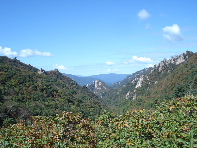
The view into the valley

Lounging on the backside.

The return trip. I just love this tree. I think I have about 20 pictures of it alone!

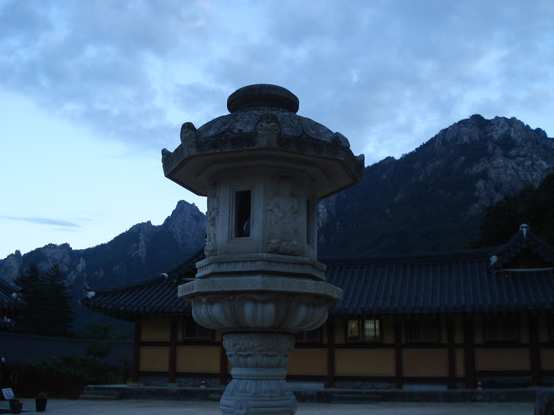
Sinheungsa Temple located at the Seorakdong entrance.
All in all, the whole route took us about 3h30, and after a delicious meal at one of the local restaurants, it was time to rest in preparation for the morrow.


A great stone seated Buddha, also located at the Seorakdong entrance.

Hiking the Cheonbuldong Valley. Lots of stairs were involved.

This portion of the route followed a river (stream?) with a pleasing number of small waterfalls and rapids.

Heading up! 

One of the lovely views.

I loved the play of light on this fallen tree.

And just the fall colours in general. We really couldn't have asked for better weather.

Crags! That's the East Sea (Sea of Japan) over there in the background.


The view from atop a crag (this is what happens when you hike with rock climbers).

Beauty.

Looking down into the valleys.

And over toward the mountainous north. I'd say that the furthest mountains are likely to be (at the very least)  in the DMZ.

At the 9.8km point.

Fall colours.
To say it got a bit foggy is probably and understatement.

The view from the top.

Descending into Osaek.
Since none of us were quite ready to return to Gwangju just yet, we decided to catch a later bus back the following day and spend the morning and early afternoon enjoying the city and the beach.

Sunning on the rocks by Yeongnangho lake. That's Ulsanbawi you can see in the right-hand portion of the background and Daecheongbong to the left.

The lovely (and somewhat chilly at this time of year) Sokcho beach.

A final view.