As Beijing provides one of the only ports of entry into North Korea, the city was initially labeled in my mind as a 'necessary stop-over' on my North Korean holiday (bet that was a sentence no one ever expected to read!). As I had a few extra days on either end of my trip and other friends who would also be passing through Beijing around the same time (and, who were actually planning to visit it) as well as a friend from highschool who was living there, I decided that maybe I should take five days to look around and explore.
Best decision I could have made. I ended up loving Beijing, when at best I'd assumed I'd just like it immensely. Perhaps I should explain, I had nothing against going to Beijing, in fact, I knew for certain that I wanted to go at some point. I also knew, however, that I would likely end up spending quite a bit of time there on later travels and did not wish to over-see it. Looks like that one's not an issue! 5 days was no where near enough! Oh, don't get me wrong, there are bad sides, the massive crowds, the pollution (which fortunately was not too bad while we were there), the summer humidity (also no where near as bad as usual) and the fact that most people just push and shove their way around you. But I just ended up loving the grittiness of it. The multi-layered history, shiny modernity and grimy-underbellied-ness of it. I also loved the contrasts between it and Seoul. People have often told me that Seoul is just a dirtier version of the major Japanese cities (not having been to Japan, I wouldn't know). If that's the case, then Beijing is their much much dirtier (I'm thinking just rolled around in the mud and then jumped in a sand pit-dirty) cousin. But it's also so much more than that. And it's not that it's 'dirtier' per se, it's more that you can feel the accumulated weight of centuries living side by side with you in an enclosed space. Or maybe it's just that, as the older narrower parts of the city act as both tourist attractions and residential areas, it's impossible to have that wide-boulevard shiny-clean feeling everywhere - well, except for where they've torn the old traditional residential hutongs down and put in glossy new purely retail ones. Thankfully they've stopped doing that due to public outcries. And it's definitely better that way, it's that closed in sense of breathing in life the way it's lived that makes Beijing so special - and I wouldn't have liked it nearly so much with out it. Then again, after living in conservative Korean society, it could also just have been the nonchalance of all the old men sitting out in the summer heat with their shirts rolled up to their armpits and their beer bellies exposed that attracted me to the city - but somehow I don't think that was the case :P.
A walk - Qianmen to Donghuamen
 |
I just loved this guy. The old hutong area near my hostel (located to the west of the
touristified Qianmen hutong area) |
 |
| Your pick of communist paraphernalia |
 |
| Bordering Tienanmen Square on the south side, this is Qianmen (literally 'front gate') or, more properly, Zhengyangmen. It was built in 1419 during the Ming dynasty and from then onward formed the southern entrance to the inner city (and therefore acted as the guardian of the entrance to the imperial city). It was, and still is, the tallest of the gatehouses and was the gate through which major processions passed. While the walls no longer stand, passing through security at the subway Qianmen station in order to cross the road and enter Tiananmen makes it feel as though they still do! |
 |
Monument to the People's Heroes, Tiananmen Square
|
 |
| The Beijing National Museum (a must do when I return) |
 |
| Awaiting the changing of the guard (sadly not as impressive as one might expect) while looking toward Tiananmen (that's the name of the main gate into the imperial city, built in 1415) and a portrait of Mao |
 |
| Tiananmen |
 |
The delicacies on offer on Donghuamen Market Street (yes, those are incredibly tiny sharks you can see there!)
|
 |
| And moving a little further down the line, we come to... |
 |
| We weren't entirely sure what gave these particular centipedes their 'diet' designation |
 |
| Snake! I wanted to try, but was sadly too full from dinner. Ah well, next time! |
 |
| These I did not want to try. We later came across a vendor skewering them alive |
 |
| My friends, it would seem, had no such reservations... I blame this on the fact that they're South African *insert sage nodding here* |
 |
Mmm, delicious!
No, really. They assured me that they were not at all bad, much tastier than silk worn larvae (hard not to be) apparently. |
 |
| Maybe it's just me... but don't you think they look a little too crunchy to be appetizing? |
 |
| Tiananmen by night. |
 |
| A stream of kites - you see these sold everywhere in the evenings. |
The Great Wall!
Made from a series of walls, ditches and other types of defensive fortifications, the Great Wall was built in various stages and phases, always with an eye toward protecting China's northern flank from invaders. While it fell into occasional disuse when invaders occasionally over whelmed the wall and took power, it's construction spanned millennia, beginning in the 7th century BC and continuing (sporadically) up to the early 17th century AD.
(A brief note here: It was amazing! I want to go back! Heck, I wanted to stay and just keep trekking it forever! We got lucky and our hostel was offering tours to a not-quite-yet-open portion of the wall near the Shixia Pass. It was both stunning and thankfully void of the massive amounts of tourists that we could see en route swarming the battlements at Badaling. Even nicer, however, was the fact that after some trekking, we made it passed the soon-to-be-open reconstructed portion of the wall and onto the unreconstructed portion. It was both great to see and loads of fun to hike!)
 |
| Climbing the Great Wall. |
 |
Yup, climbing.
|
 |
| Looking out the guard tower at the view of the ancient Mongol side. |
 |
| Sorry, there are going to be a lot of these - it was just so breathtaking! |
 |
| Those are trees, not grass, brushing the walls. |
 |
| Starting to get rougher. |
 |
The white bit in the top left shows you how far we've come.
So gorgeous. One day, I'm going to hike the whole route... or try to anyhow. |
Not tired enough from our activities, we decided to walk to and climb the hill in Jingshan Park for a view of the sunset over the Forbidden City
 |
| A view of the top. Jingshan park lies directly north of the Forbidden City and used to be an imperial garden. It's is now a public park most notable for it wonderful views, dinosaur collection (seriously) and as the location of the suicide of Emperor Chongzhen (the last of the Ming Dynasty emperors) upon hearing that the wall had been breached in 1644. Rather impressively, the hill was constructed during the Ming dynasty for Feng Shui purposes and as a repository for all of the soil excavated during the building of the moat around the imperial palace. |
 |
| Looking westward. |
 |
| Looking northward |
 |
| Looking eastward toward the shiny new business district of Beijing |
 |
| And, finally, southward, over the Forbidden City |
 |
| A gatehouse and the moat. Beautiful. |
The Forbidden City & North
 |
| A lion guards one of the main pavilions at the Hall of Supreme Harmony |
 |
| In the outer court |
 |
| Peace within the throngs |
 |
| The Hall of Central Harmony (left) and the Hall of Preserving Harmony (right) |
 |
| and to capture the colours... |
 |
| There's something charming about a decaying ruin. Not so charming that I'd want the Forbidden City to rot though! |
 |
| The Imperial Garden |
 |
| North (and out)ward toward Jingshan |
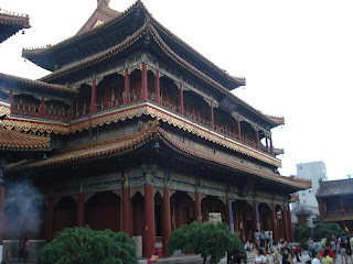
The Lama Temple
 |
| The entryway |
 |
| Originally built in 1694 as a residence for the Qing Dynasty Court eunuchs, it did not become a temple until 1722. Now a lamasery (a monastery for Tibetan Buddhist monks) the Lama (or Yonghe) Temple is one of the most important Tibetan Buddhist Temples outside of Tibet. It is considered the national centre for Lama administration by the Chinese government. |
|
|
 |
| The Hall of Harmony and Peace |
 |
| It's centrepiece, a 26m tall Maitreya Buddha built from a single white sandalwood tree. |
 |
| Incense for prayers |
 |
| a view of the roof |
 |
| Durian with friends. Yes, that is a normal reaction... |
The Northward to the Lakes
 |
| The Shichahai nightlife. The area is absolutely lovely, lively any time of day and composed of three joint lakes: Qianhai, Xihai and Houhai bordered by hutong areas and historic sights. |
 |
| lucky crickets anyone? |
 |
| The Tea Master in his shop. Well worth a visit. Will post the address as soon as I find it again. |
The Temple of Heaven
Used by many successive dynasties to perform ancestor worship and prayers for good harvest, the Temple of Heaven was originally built under the directive of the Ming Yongle Emperor (who is also responsible for the construction of the Forbidden City) from 1406 to 1420 and later renovated in the 16th and 18th centuries.
 |
| A peak at the Hall for Prayer of Good Harvests. The grounds surrounding the Temple are absolutely massive and are used by locals for all many of sports, activities and gatherings. |
 |
| The Hall for Prayer of Good Harvests |
 |
| Peaking over the wall |
 |
| Looking back through the gates whilst crossing the 360m Vermilion Steps Bridge. |
 |
| and south to the Imperial Vault of Heaven. |
 |
| The Imperial Vault |
 |
| Looking up. |
The Summer Palace
A Ching Dynasty (17th-early 20th centuries AD) retreat consisting of gardens, temples & pavilions built on and alongside Longevity Hill (Wanshou Shan) and Kunming Lake, it's difficult - if not impossible - not to love this place.
 |
| A view to the East after entering the northern gate. |
 |
| The matching west-ward view. |
 |
| Hiking Longevity Hill. |
 |
| A view from the top. Overlooking the Temple of Buddhist Tenets. |
 |
| Sea of Wisdom Temple at the top |
 |
| The Temple of Buddhist Virtue with Kunming Lake behind. |
 |
| Boats! |
 |
| Looking up toward the Temple of Buddhist Virtue from the Cloud Dispelling Hall. |
 |
| The Cloud Dispelling Hall |
 |
| Kuming lake and Empress Dowanger Cixi's Marble Boat (actually built during the 18th century reign of the Qianlong Emperor and restored by Cixi in the late 19th century) |
 |
| The view from our pedal boat |
 |
| Looking out toward South Lake Isle and the Dragon King's Temple |
 |
| Forward toward the Wenchang (Flourishing Culture) Pavilion |
 |
| At the Zhichun (Perceiving the Spring) Pavilion. |
 |
| The perfect way to end a day. |
and, last, but never least:
 |
| The Birds Nest Stadium by night. |


