Showing posts with label Bicycle. Show all posts

Wednesday, November 6, 2013

Dragons in the Mist: Hạ Long Bay & Cát Bà Island

Probably one of the biggest tourists attractions in Southeast Asia (and certainly one of my reasons for wanting to visit Vietnam), is Halong Bay.

The karst islets of Halong Bay. I was here in March, in the summer, the gulf shows off it's incredible turquoise hue.

Located along the Northeastern coastline of Vietnam in the Gulf of Tonkin, Halong, or Descending Dragon Bay, is made stunning by the 1,600 karst islands and islets that dot it. 500 million years old and formed by 20 million years of erosion in a wet tropical climate, Halong truly is a marvel. It gets it's name from legends which claim that the islands were formed by dragons sent by the gods to protect the Vietnamese against invaders.

Looking outward from Cat Ba, the largest of the islands.
The most common way to explore Halong bay is by two or three day cruise on a (hopefully modernised) traditional junk boat. These cruises often include a stop at one or more of the incredible karst caves which riddle the islets, the opportunity for 2 or so hours of kayaking (at your own speed) around, under and through some of the islets at one of the floating villages, the chance to jump in for a swim (in the admittedly now polluted waters), excellent eagle watching opportunities and fairly decent food. Given the plethora of tours available and the range of prices and reputations, it's best to do a touch of research before you book. For the younger crowd looking for more adventure and a good party, Central Backpackers in Hanoi offers the perfect tour.

Fishing boats moored in a place we nick-named 'Pirate Cove' on Cat Ba. 
For the budget traveller, the cheapest way to get there is to organise a combined bus and boat ride out to Cat Ba Island from Luong Yen Bus Station in Hanoi (should be 10USD each way), or to get there by boat from Haiphong on the main land and to use Cat Ba as your jumping off point. Just be warned that there are several ports on the island and that if you arrive on the opposite side late in the afternoon, it might be difficult to find a ride across the 30km island into Cat Ba Town. The Island itself is stunning, the food there delicious (check out Hoang Y in Cat Ba town for the best there is), and the boat tours out onto Cat Ba or Lan Ha Bay, which boast the same landscape as Halong, much cheaper and less crowded. There is also plenty of cheap accommodation on offer on the island, beautiful beaches, excellent hiking, rock climbing and biking and, for those who want to get out on the water, the awesome Asia Outdoors offers kayak and deep water soloing trips. 

One of the beaches near Cat Ba city. Beautiful during the day, but arguably cooler by night when the algae in the water shoots off sparks of electric green bioluminescence in your wake.
Cat Ba is the largest of the 366 karst islands in the Halong area and, in addition to all of the activities above, boasts incredible scenery and biodiversity, with a national park comprising more than half the island. The park offers some great hiking trails, awesome rainforest insects, 1,561 recorded species of flora and fauna, and is home to the extremely endangered Cat Ba golden headed langur (of which there are only 68 left in the wild). It's easy enough - and well worth it - to just rent a motorbike or bicycle (be warned, there are lots of big hills) for day or two and explore on your own.

The view from the base of one of the trails in Cat Ba National Park.

Monday, April 1, 2013

Loitering at the base of the Mekong Delta in Ha Tien

For much of history, what is now Vietnam's Mekong Delta actually belonged to Cambodia under the ancient Khmer empires. Laced with rivers and streams, boats are the the primary mode of transport in the area - though local buses-come-delivery-vans also trundle their way along narrow streets with rice paddies, coconut groves and water buffalo lining their sides. The area is beautifully verdant - especially in contrast to the dry season in Cambodia. I don't think I understood the true meaning of lush until I crossed the border! As many of the area's residents are ethnically Cambodian, there was little change in culture apart from the sudden appearance of the ubiquitous traditional Vietnamese conical hats.

The Beach at Mui Nai
While the most common way to visit Vietnam's Mekong Delta is on a day trip to the lovely towns of My Tho and Ben Tre from Ho Chi Minh City (Saigon), I decided to hop on a local mini bus from Kep in Cambodia to the tiny Prek Chak-Xa Xia border crossing in the far south and hitch the 10km to Ha Tien.

A view of the buffalo filled rice paddies from Thach Dong.
What became immediately evident upon renting a bike and setting off to explore the area, was how few foreigners actually stay in Ha Tien beyond the few hours necessary to catch their next bus or ferry -and how glad I was that I actually had. I'm not sure what the best part of that 15km cycle was: buying roasted bananas encased in rice and palm leaves from local ladies on the side of a rural country road, getting into an epic splash fight with two adorable local 8 year old girls when I stopped off at the beach on the Mui Nai peninsula to cool down in the (rather warm) waters of the Gulf of Thailand, or exploring the Buddhist Temple built inside the bat-filled Thach Dong Cave. In any case, the day also ended wonderfully with explorations of Ha Tien's treat-filled night market and local kids playing bumper carts on the water-front promenade.

Saturday, October 20, 2012

Cycling through Fields of Gold: a Visit to the Ancient Silla Capital of Gyeongju Day 1

A few weekends ago, I took advantage of the fact that all of my friends would be out of town or otherwise busy and snuck out to explore the ancient Silla capital of Gyeongju (경주) on my own. While I wouldn't have minded company, it was probably better that I had no one else with me - it allowed me to engage in some hard core archaeophilia without doing so at the expense of anyone else!

A Silla-style pot sits in front of one of the many ancient burial mounds of Gyeongju.
I'd previously heard mixed reviews of the city, and it may be the archaeologist in me coming out, but I absolutely loved it! Fairly small for such a famed city and located nearly on the coast, four hours east of Gwangju, Gyeongju was home to the Silla Dynasty, which lasted from 57 BC to  935 AD, and ruled a unified Korea from the 7th to 9th centuries AD (after conquering the western Baekje Kingdom in 660AD and northern Goguryeo in 668AD). Because of this, Gyeongju is, unsurprisingly, home to a great many Silla Dynasty Treasures - chief among these (in my opinion at least) are the burial mounds.


Hwangnam Daechong (황남 대총), a double tomb likely containing both a king and queen,  located in Gyeongju's Tumuli Park (대룽원 - Daerungwon).

The Tumuli are scattered all around the city, and many of these can be visited for free. The best concentration of these, however, lies within Tumuli Park (entry 1500won, open 9am-10pm). The park is located in the city centre and beautifully landscaped with atmospheric music played on speakers throughout. This is not what makes it worth visiting, rather, it's the access to Cheonmachong (천마총 - or Heavenly Horse Tomb), the only tomb in Korea that visitors are permitted to enter. Named for the design on one of the artifacts found (and now displayed) inside, the tomb likely belonged to a 6th or 7th century king. I know I may be a bit biased, but it is definitely worth it. The reconstruction of the burial as it was found, as well as the richness of the artifacts on display are wonderful. It's also worth visiting if only to get some idea of just how astonishingly big these tombs are inside!

The entry into Cheongmachong. No pictures of the inside. I was far too distracted by the actual contents and it felt a bit disrespectful to be taking any. Definitely worth a visit though!
As many of the city's main sites are located within a 3km2 area (and the not-so-main-ones within 10km2), the best way to visit them (in the spring summer and fall at least) is on foot or by bike (available for rent at the bus station for 7000won/day or south of Tumuli park for 5000/2hrs or 10,000/slightly longer day).  There really was loads to see but, rather than overwhelming you with photos of (some might say far too many) tomb mounds, farmers fields, museum displays and archaeological sites, I figured I'd only post a few.

Possibly one of the most famous sights in Gyeongju, Cheomseongdae (첨성대) is an astronomical observation tower built during the 7th century reign of Queen Seondeok and located in what is now Wolseong Park. It is lit up particularly nicely at night.
The tree covered rise in the background is all that remains of Banwolseong (반월성 - literally Half Moon Fortress) or Wolseong Palace. The hill is now home to lovely walking and cycling paths and not much else - well, except for the ice storage celler which has mysteriously survived.


The Emille Bell at the National Museum. Known as the Bell of King Seongdeok, this bronze bell weighs at least 19 tons  making it one of the biggest not only in Korea, but the world. It dates from 771 AD and legend has it that when it was first cast, it wouldn't ring - or at least not until it was melted down alongside the body of a young girl and the mixture recast. That's why, when rung, the bell makes a sound like 'emille' (pronounced like Emily), the word for mother in the Silla dialect.

Two of the Museum's workers wander the grounds. A picture of archaeological delightfulness I just couldn't pass up - I don't ever recall dressing like that :P.
The remains of a Silla necklace. Silla could easily be renamed the golden kingdom. This is nothing compared to the many pure gold crowns and other pieces of jewellery housed at the museum. There is also a wealth of pottery (including duck shaped pots!) and weaponry there from a period spanning nearly a millennia.  
For all my gaming friends: Why, yes, this is in fact an ancient oak D14! With six square and eight hexagonal sides, this dice was used by nobles in ancient Silla to play what we now call drinking games. Each side contains a command to be performed by the die caster. Check out the commands below. 
Command translations for the die above.
While there is no dearth of sights in the city centre, there were a number of less important, but interesting sounding sites further to the south at the base of Namsan (the montain to the south of the city) that I also wanted to visit. Thus, armed with my trusty steed of a girly pink bicycle (complete with front basket and streamers) and directions secured from the gate keeper at the National Museum - who assured me that it was very far for a girl to cycle at 5km away through many farmers fields - off I went.

Fields of goldenly-ripe rice! One of the reasons I wanted to see the sites of Gyeongju in the fall.

Harvesting the rice! This is a sight to be seen just about anywhere across Korea at the moment.

Rice! With an ancient Pagoda in the background. Cycling the narrow paths through the rice paddies was truly a delight (even when the sky opened up and I got rained on). The only problem was trying to watch where I was going and not veering into the fields looking around me - something that nearly happened more than once...
One of the many smaller sites, Poseokjeong (포석정 -Stone Abalone Pavilion) provides further proof (as if any was needed) that Koreans (past and present) really like their drinking games. Once an Banqueting Villa for the Silla Kings, all that remains is this this 6 meter long trench. In times past it was filled with running water and one person placed at each end. The person at the head would come up with a line of poetry and place a drink in the trench at their end. If the cup got to the other person before they came up with a suitable second line, they were required to down said drink. Sounds like a pretty solid game to me!

More fields. It's silly, I know, (and probably marks me as a city girl as well), but I somehow never clued in that ripe rice would be golden in colour. I always just envisioned it as green!

After finishing my rounds and dropping off my bike, it was time to check out Anapji (안압지) pond at sunset. Here is what I encountered on the way.

What I believe to be the Lotus Flowers Complex at Anapji.
A closer view of one of the hedge flowers.

A Heron! (or is it a stork?) There were a number of these alongside ducks in this part of the park.
The fields at dusk. 
Anapji at night. The reflections just make this look too cool!
A man-made lake first designed by King Munmu in 674 AD to reflect the shape of his kingdom after unification, the location was also the site of the breakdown of the Kingdom as it was here that King Gyeongsun later handed over power to the founder of the Goryeo Dynasty in 918 AD. 
Once a much larger complex, and called Wolji at the time, three reconstructed pavilions are all that remain. Anapji is located directly west of Banwolseong and has provided a host of archaeological treasure, most of which are housed in a special building at the National Museum. 

Friday, July 13, 2012

Cycling in Gwangju

Last weekend I (finally) managed to take advantage of some gorgeous weather and the need to run errands, and went on my first true bike ride around town since arriving here. Well... I suppose that's not entirely true. Having been so excited about finally acquiring a bike and the time to use it, I also went on a bike ride the weekend previous  - in the pouring rain (sorry Jason for dragging you along!). While monsoon season was due to start a month or so ago, it only truly started two weeks ago, just in time for me to insist on riding my bike :D. It was actually a great deal of fun (I rode in the rain plenty while living in England, but never in a true downpour!). It was not, however, conducive to taking pictures. This past weekend's ride was just the opposite, with gorgeous nearly clear skies allowing for some lovely photo ops. Check out the pictures below to see some of the sights I regularly see on my bus rides into town.

Gwangju proper from the West with Mudeung Mountain in the distance.

Looking southward along the main branch of the river. This is Sangmu or 'New Downtown' district of Gwangju. (I actually live quite close to the 'NewNew Downtown' District which is quite wonderful, but of which I, sadly, have no pictures since it seems to be raining whenever I go!)
Some lovely paths and parks along the river. One of the things I love most about Korea is that no space ever seems to be wasted. Parks, sports fields and outdoor workout stations fill any available spaces - including those located under overpasses!
Crossing the river into down town after it curves eastwards.
Northward toward some high-rises that seem to permeate every Korean city.
While I thoroughly enjoyed my ride into town, it was possibly one of the most harrowing rides I have ever undertaken. I live out on the west side in an area that is separated from the rest of the city by two arms of the river and the expansive area of floodplain between then. Rather than cycling the winding route along the river, I'd decided to take the more direct route along the roads. While the freeways and overpasses were quite comfortable to cycle, with wide and well maintained cycle paths, these all but disappear on the larger, non-freeway, roads and cycling becomes either a fight not to be run down by the buses (who I previously thought only had it out for motorists and pedestrians, nice to know they choose their targets in a fair and equitable fashion :P), a jungle expedition through thick tall grass, or a game of thread the bike through the cars parked up on the sidewalk (this latter route, though time-consuming, soon became my favourite). While I've been told by many cyclist friends that my normally 45min bus ride into town is much faster on a bike, this route took me nearly 1 hour and 30 mins! I'm not sure whether this is due to my inability to cycle rapidly, the thirty-some-odd degree heat (Celsius), the amount of times I stopped for photos or the fact that I have no gears on my bike. Non-the-less, it was a thoroughly pleasant ride.

After finally making it into town and running all my errands, I saw that I still had plenty of time until dusk and decided to check out some of the sights that I had here-to-fore not had the time to see. Chief of these was 5.18 memorial park in Sangmu, which celebrates the lives and deaths of the  hundreds to thousands (the death toll is not known) of Gwangju citizens (mostly students) who took up arms from May 18th to 27th in 1980 and died fighting for democratic rights for all Koreans. Known as the Gwangju Massacre, the event and the sacrifice of the martyrs is considered significant by all Korea, with May 18th established as a national holiday. It carries a special weight here in Gwangju where the incident occurred and where many people remember the event and victims personally.

The park itself is absolutely lovely (as any park celebrating life, liberty and perseverance really should be), with lovely monuments, bike and walking paths, fountains, workout stations and shrines. The atmosphere is also supremely friendly and warm, with people greeting one another and conversing with strangers. There was even an older man playing the accordion at one of the pavilions and a group of flute playing university students at another to complete the experience. It was almost impossible to remember that one was right in the heart of downtown!
5.18 Monuments


The monument from behind.
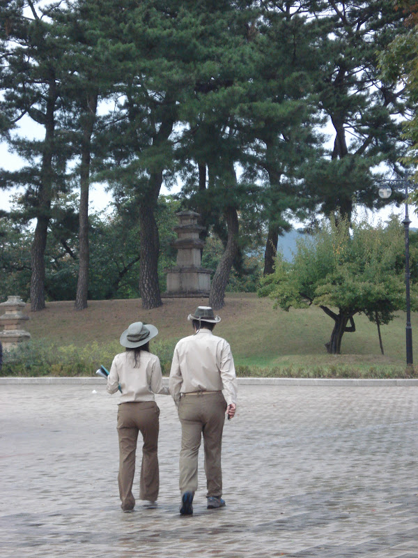
The pagoda atop the hill in the park.
A view from the pagoda toward the Northwest where I live, you can see the flood plains behind the buildings and the "New New Downtown" area even further behind.
Looking Southwest-ward toward the 'New Downtown Area'.
Looking to the East
To the East with Mudeung and Old Downtown. Check out the storm clouds rolling in.
The lovely pagoda and fountains at the base of the park.
Riding home along this route, I also had the opportunity to ride along the floodplains which, while not exuding the prettiest scent in the world, make for some beautiful scenery.


One of the other things I love about Korea is how friendly and welcoming everyone is. After rejoining the river for the final leg of my journey home, and just as my stomach was beginning to make itself known, I was waved over by two young families (with 3 lovely children each!) who were having a barbecue under a bridge. Inviting me over and sitting me down, they ensured I was well fed as we watched the sun set over the river, stuffing me with meat, beverages, mouth watering sea food, side dishes and desert (the children were insistent that I share their cookies and fruit). Such warmth is both incredible and normal. While I was a special guest in the sense that I was a foreigner and, so, the adults had many questions for me and the kids delighted in showing me their English, many passing Koreans were waved over as well and such sharing of food is a regular practice when eating outdoors. Love it!
  
The kids playing along the river.

The bridge after sundown.

Looking toward the Wolgok-dong/Hanam area at dusk.