A few weekends ago we got to enjoy a rare long-weekend thanks to the Buddha's Birthday. While the birth or your main deity might seem to be cause for some major celebrations, Buddha's Birthday is actually a rather subdued affair here in Korea. In keeping with Buddhist themes of introspection, there are no extravagant parties. That being said, the majority of public spaces so tend to be festooned with lanterns in the weeks leading up to the holiday, which gives the world a lovely festive air. Traffic is also largely impenetrable on the roads leading past major temples on the day - although from listening to my Korean friends, I'm not entirely sure how much of this is due to the date and how much to the free bibimbap (mixed veggies (and sometimes meat) on rice) on offer to all visitors -_~.
At any rate, I (and a number of others) took advantage of the added day off to travel. Given that I had an extra day, I decided to travel as far away as possible while remaining (just barely - more on that later) within the borders of Korea. Although I had initially thought to attempt it on my own and get some hiking done, I managed to hitch a ride with a group of similarly-minded waygooks (foreigners) and a local guide who is working on growing his business (If you're living in the Gwangju area, definitely look up Pedro Kim and his Lonely Korea weekend trips). What a great ride it was. While I didn't get any hiking done, the access to all the major sites along the coast (as well as the camaraderie and great food) provided by Pedro and his van made the trip well worth it - even if the return journey was 11hours!
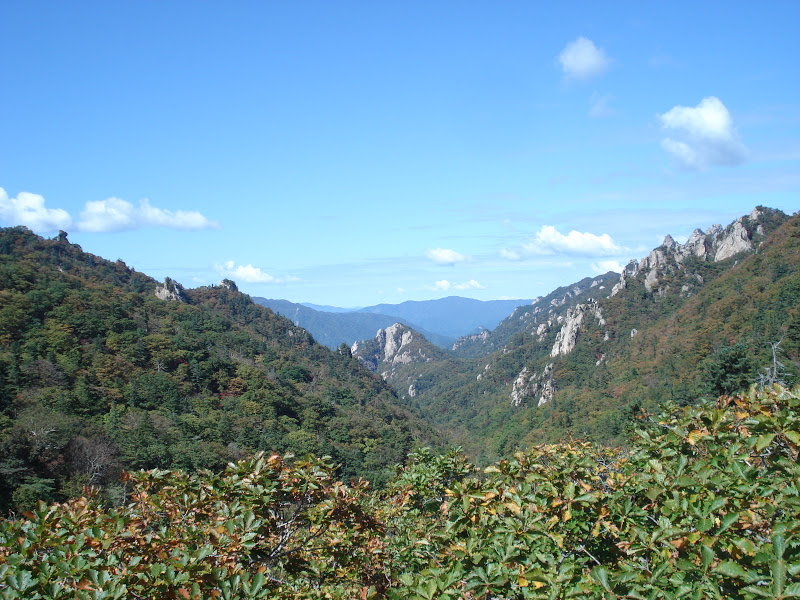
For those of us living in Gwangju getting as far away as possible while remaining in the coutry means heading up to the northeastern province of Gangwon - and what a beautiful province it is. I'd been told previously that Gangwon-do or 강원도 (-do in this case means province) was the most mountainous in all Korea. Hearing that, I have to admit that I scoffed a little. As you may have noticed from my previous posts
all of Korea is mountainous. I definitely had to swallow that scoff once I arrived. It's true, Gangwon-do is just that much
more mountainous. It's breathtaking really. It's also got gorgeous pristine white sand beaches extending all the way up the clear, aqua-blue coast. I'm already counting down the holidays until I can go back!
After departing Gwangju early on the Saturday morning, we started our journey by heading through some of Korea's historical heartland until we reached Pohang on the East coast. Known for it's crab, this city would have been my childhood idea of heaven. Not only were the critters (large sized, in a range of species and perfect for eating) available absolutely everywhere, the whole city (despite being known for it's steel work) seems to have jumped on the crab theme, with large crab statues and crab-onspired architecture visible all around. Sadly, I was too entraced to have taken any photos.
I did, however, manage to snap some shots of the beautiful blue East Sea (called the Sea of Japan by some, though never by those in Korea) and some local crab-collectors.


From there, we continued to travel up the coast - a spectacular drive with mountains on one side and sea on the other. We stopped only once we'd reached the last thing I ever expected to find in relatively conservative Korea - the lovely and yet completely inappropriate-seeming Haesindang park (해신당 공원). Located to the south of the city of Samcheok (삼척), it's seeming inappropriateness stems from the fact that the park is filled with very detailed and very large phallic statues. This is not an accident. An ancient story goes that an ill-fated couple were separated by the tide and the young maiden was lost to the sea when her young man failed to save her. Shortly thereafter, all of the fish disappeared from the area, devastating the population of the small fishing town - that is until a fisherman one day couldn't wait to get to shore to relieve himself and, so, peed into the ocean (something I suspect is not all that rare of an occurrence). Mysteriously, a few fish reappeared right after, leading the village folk to concluded that the maiden's frustration at dying a virgin had been what was keeping the fish away. To reconcile this, the villagers built the park. Rather interestingly, the town's prospered ever since ^_^. Many of the statues are actually phenomenal in terms of the artistic ability that when into making them, others can be a bit... er... over-the-top? Never-the-less, I enjoyed the park a great deal more that I ever would have thought, and the statues are nicely complemented by the absolutely fantastic scenery surrounding them. Craggy Beaches and lush mountainsides can make anything look appropriate. I definitely recommend going if you ever find yourself out that way.
 |
| The poor lost maiden. |
 |
| The lovely ocean view. |
I have to say that the most disconcerting thing about that park was the fact that many grandparents and young families seemed to think it was the perfect place for a picnic on a weekend afternoon - in spite of the fact that Korean's do not even believe in kissing in public!
Or next stop along the way was the justifiably famous and absolutely wonderful Hwanseon Cave (환선동굴 - Hwanseondonggul). This limestone cave system is situated halfway up a mountain and runs for 6km, only 1.6km of which is open to the public. Even if I didn't love rocks and caves I think I would love that system. It's just enormous! The largest chamber runs 100m by 30m and is so vast that you can barely make out the other side in the dark. In true Asian fashion, publicly accessible section have been done up with strings of neon signs and whimsical signs that somehow manage to just about convey what you are looking at. None of this takes away from the splendour, however (it rather adds to it I think), as the cave are just that fabulous. Check out the pics below. There is one slightly iffy aspect, the spooky statue of a monk who retreated into the caves and never returned. The story is fine, the statue is... well... I feel bad maligning it, but it's somewhat terrifying.
 |
| Entering the maw. |
 |
| Checkout the shape of this hole! |
 |
| Awesomely coloured flowstone. |
 |
| Okay, I'll stop with the rocks now. |
 |
| Spooky, no? |
After our lovely caving expedition, it was time to make camp (or, in this case, find a traditional minbak) and partake in a lovely barbecue.
The next morning, there was some time to wander and lounge on the beach (despite looking a beautifully welcoming blue, the water was still a temperature that can only be described as frigid. I only ever made it in to my upper thighs at any of the beaches, I console myself with the fact that that was still further than most and that I'd likely have gone in all the way had we not encountered a downpour at midday), before heading off to Jeongdongjin (정동진) to check out the American Warship and North Korean submarine currently located there.
 |
| A morning walk on the beach. |
 |
| My beach-combing intake for the morning. |
 |
| A fishing boat departs for the day. |
First stop, however, was the lovely Jeongdongjin beach. While one can really never see too many of those, this one is special for a number of reasons. Cheif among these is the fact that this beach contains a magnificent large hour glass on tracks, meant to symbolise the time spent in separation and the inevitable reunification of the two Koreas and many families torn asunder.
 |
| The moving hour glass. |
Another reason this park is pretty high on the must see list? Well... I'll just show you.
 |
| Why yes, that is a large cruise ship you search perched on a cliff before you. |
 |
| See, told you! Well... Okay, so I may have lied. But, in my defence, that was the look the Sun Cruise Hotel was going for :). |
And the final reason? It is home to Korea's only beach-side train station. While this might not seem to be that big a deal, I mean I have certainly seen many such train stations in my life, it is particularly significant given the proximity of this beach to North Korea (about 100km). From here northward much of the shoreline, though still accessible to beach-dwellers, is lined with barb wire and closely guarded. See the following picture for an example. Korean are also enamoured with this train station as it featured in the Korean soap opera (or K-Drama) "Hourglass" (Korean's and their soap opera's... a head shake is all the response I can give here. As my local corner store owner just whispered to me conspiratorially moments ago, never taking his eyes away from the TV screen while he rang through my box of choco-chip cookies (now sadly empty), "한국 사람 케드라마 좋아해요" or "Korean people like K-dramas.").
 |
The adorable but-not-too-exciting-for-those-used-to-such-things Jeongdongjin Train Station.
|
 |
| A South Korean guard outpost overlooking the East Sea. |
Returning to the topic of National Security (though I imagine that many of the soldiers likely also spend a great deal of time watching the K-dramas on their hande-pones (handphones) - either that or Starcraft games, those seem to be the entertainment of choice for young men while on the bus), the above photo is actually taken at Tongil (통일), or Unification, Park, which is located just up the beach and houses a former US-warship used by the South Koreans during the Korean War and a beat-up North Korean (yes, genuine North Korean) submarine which ran-around with it's 26-man crew (although by the time shore was reached the 11 civilian staff members had been killed and all classified documents burnt to avoid any information leaks) while on a surveillance mission in 1996. The ensuing manhunt lasted 49 days and resulted in the loss of 17 South Korean lives and 13 North Korean soldiers, the capture of another North Korean soldier and the mysterious disappearance of the final one. I have to admit, my prevailing thought while touring the sub was "how on earth did they manage to fit 26 people in here? I'd barely survive being stuck in here with 2!"
 |
| The positively tiny sub and the damage done to her tail when she struck the rocks. |
 |
| For comparison - trust me though, it was teeny! |
Next stop was Gangneung for BBQ supplies and then to the beach for some relaxation (unfortunately the rain drove us away from Gangneung beach, so we decided to continue heading Northward and find a place there in order to better prepare for the next day's adventure (and 11 hour trip home)). Finding a small isolated beach, we decided to settle in for the night (rather than camping in the rain, we once again settled for a minbak. This one was, rather endearingly, named the 'Vancouver'). After a delicious BBQ of chicken skewers, dakgalbi and s'mores, we trapsed down to the beach to partake in what is arguably one of Korea's national summer pastimes - firework displays! given our proximity (about 30km) to the North Korean border, this likely wasn't the wisest choice, but the South Korean patrolmen who came by (yes with guns) seemed to find us more amusing than threatening and even stuck around to watch.
 |
| A calm late afternoon beach. |
 |
| Me wading into the absolutely frigid water. |
Proof that it's a national passtime - even the little one has a roman candle.
Despite the (arguably appropriate) grey-ness of the day, we got an early off to an early start, departing for our final stop and ultimate goal immediately after our deliciously scrumptious breakfast. While the whole trip was filled with fascinating and unique sites, it could be argued that this one was the most thought provoking. You see, our final stop was the Goseong Unification Observatory from which we were able to see over the 4km of the (incredibly well-preserved and ecologically rich) DMZ and catch a glimpse into North Korea. While we weren't able to see much from a anthropological point of view, the landscape itself was stunning and the situation certainly one to contemplate.
 |
| Across the barbed wire. Most of what you can see is the DMZ. The far range however, is North Korea. |
 |
| A closer look. |
 |
| Looking inland. |